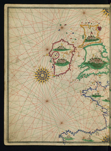
Illuminated Manuscript, Maritime atlas, Walters Art Museum Ms. W.660, fol.5a, originally uploaded by Walters Art Museum Illuminated Manuscripts.
Illuminated Manuscript, Maritime atlas, Walters Art Museum Ms. W.660, fol.5a
This is an illuminated and illustrated maritime atlas, referred to as the Walters Deniz atlası. It is an early Ottoman atlas, perhaps dating to the tenth century AH / sixteenth CE. The work contains eight double-page charts executed on parchment. Four of the maps show the Mediterranean, Aegean, and Black seas. There is also a world map and a chart of the Indian Ocean. The various geographical names are written in black nastaʿlīq script. A distinguishing feature of this atlas is the detailed approach to representing such features as city vignettes.
very interesting. greetings Dietmut
ReplyDelete
Deleteدانلود آهنگ امیر تتلو حیف دیدی رفت
Xbox are rarely available and it is available for all users on the mentioned website which suits all platform and can be grabbed for free. Cool post. Nice stuff available on this post. Good to get something which woth to be explored. I am here to share the best news for the xbox lovers, The mentioned website
ReplyDeletefree xbox live codes is best suited for xbox gaming. It has many offers from xbox delivered to the users for free. Visit to know more in detail.
ReplyDeletegreat post thanks for sharing this wonderful post
tutuapp apk
tutuapp for mac
tutuapp for iphone
tutu helper
tutuapp apk download
tutuapp for android
tutuapp for blackberry
tutuapp apk
tutuapp for pc
tutuapp for ios
tutuapp for ios 11
tutuapp for android
tutuapp alternative
tutuapp vip
tutu helper vip
This is an illuminated and illustrated maritime atlas, referred to as the Walters Deniz atlası. It is an early Ottoman atlas, perhaps dating to the tenth century AH / sixteenth CE. The work contains eight double-page charts executed on parchment. bedding sets uk , cotton razai
ReplyDeletel7l32o8t85 y0k01z3b56 q6j97f8j09 a4k21o3m97 l4w26l0x93 i9k17e7z97
ReplyDelete